The Climatology of Bhutan Booklet
The National Center for Hydrology and Meteorology (NCHM), Bhutan, in collaboration with Regional Integrated
Multi-hazard Early Warning Systems (RIMES), Thailand and with support from the WMO GFCS Government of Canada
produced the “Climate of Bhutan” booklet in the year 2018.
The Climate of Bhutan booklet contains the climatology of dzongkhags(districts) of Bhutanbased on interim
climate
analysis from 1996 to 2013. Tmax, Tmin and Rainfall (daily value) are three basic parameters considered for
climatology preparation. The initial analysis used 68 meteorological stations, including 20 Class A (Agro
meteorological) stations in 20 districts of Bhutan and 48 Class C (Climatological) meteorology stations. For
all
class, ‘A’ stations, continuous data is available from 1996 to 2016, while for class C stations, data
availability
varies greatly, with few having insufficient climate data. The R Program with the package of RclimDex was used
for
quality control purposes.
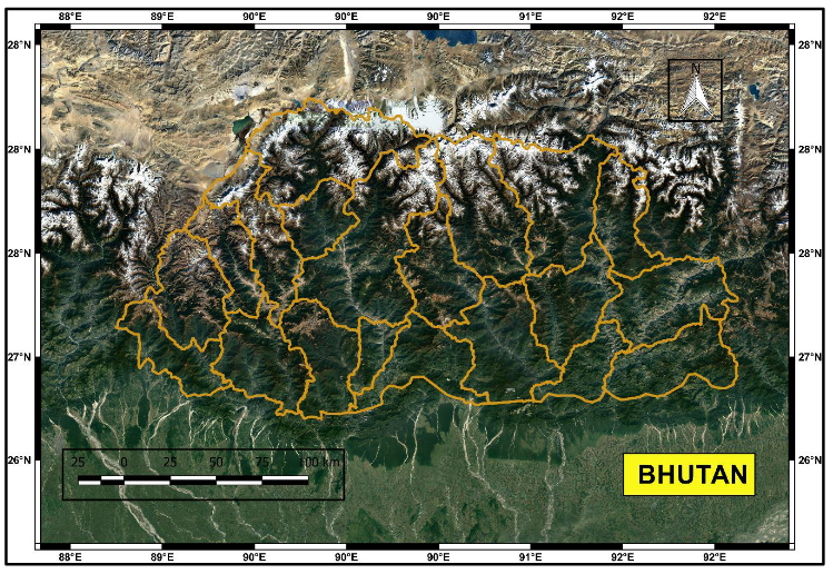
Figure 1. Physiographical features of Bhutan and surrounding areas
After an initial screening of the station using the RclimDex tool, 44 meteorological stations selected out of
68
stations to prepare the final report. The 17 stations had more than 15 years of climate data; 22 stations had
more
than 10 years of climate data and 5 stations had about 10 years of climate data. The ArcGIS software is used
for
the spatial plotting of maps. The report contains an analysis of the maximum temperature for May & June,
March, April, and May, and the minimum temperature for December, January, and February over Bhutan. Bhutan
received rainfall mainly in two seasons’ viz. summer monsoon and spring season. The winter and autumn season
is
mostly dry for Bhutan. The spatial variation of total annual rainfall during these four seasons were studied
in
detail in the final report.
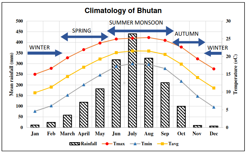
Figure 2. Climatology of Bhutan
The area of Bhutan was classified under four classes of Köppen-Geiger climate classification. Climate Booklet
contains the climatology of Bhutan district in detail using Köppen-Geiger climate classification. The final
reports also explored the Precipitation and Temperature Analysis using high-resolution gridded products from
APHRODITE’s-MA, PERSIANN-CDR, NASA’s Giovanni and downscaled projections from NEX-GDDP datasets. Finally, the
comparison was made between satellite products and station data over precipitation. The detailed report can be
found >> Here <<